Sunday, 27 March 2011

Torres del Paine, Chile - Day Three, This is the big one!

Torres del Paine, Chile. January 6, 2011. Day 3 is "The Big Day". This is the day we would hike 28 kms! Yes, 28 kms. Crazy! Why would we ever choose to do that!?! Well, there weren't many other options. The next refugio is 13 kms away, on the other side of the French Valley. But we can't just walk past the French Valley, without exploring more. A one-way trip up the French Valley is 7.5 kms. So if we want to see it all (and of course, we want to see it all!), we need to go all the way up and down the valley (15 kms roundtrip), then continue back on the 13 km trail to Refugio Paine Grande.

We started out from Refugio Los Cuernos bright and early at 8:00 a.m. The trail was constantly going up and down and it was a hot day. After a difficult 2.5 hours, we arrive at the entrance to the French Valley. Here we dropped our heavy packs in the bushes, taking just our lunches and rain jackets and continued up the French Valley, feeling much lighter. The route was rocky and steep, but the views were extremely rewarding.
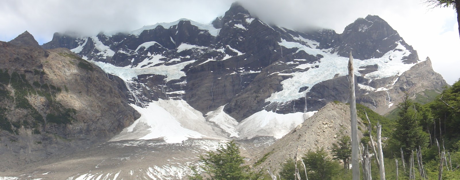


The trail led us along side a large glacier 'flowing' down the mountain. Even before we saw it we heard pieces of the glacier breaking off. It sounded like thunder; but there was not one cloud in the sky. A river of glacial run-off was rushing between us and the glacier. I craved to witness a calving of the glacier with my own eyes! We found a nice shady spot for lunch, beside the river. From there we sat and watched the glacier. We were lucky enough to see some small pieces break off. Well, although they looked small from our perspective, those pieces were probably the size of an apartment building. But compared to the size of the glacier itself, they were minuscule. (The attached video shows our lunch spot, but it was impossible to catch the glacier breaking on camera!) Click to watch video of our views during lunch.

We continued up the French Valley, eventually reaching the end of the trail and the lookout. From here we had a view down the entire valley. It was pretty impressive. And it was clear why you could not go farther as the end of the valley was blocked by a wall of mountains.


Left: A dead part of the forest, near the end of the valley.      Right: The view look back towards the opening of the valley


It was 3:00 p.m., we had started in the morning at 8:00 a.m. and we were still only half way done our day! No time for lolligagging, so we promptly turned on our heels and headed back down the valley, passing by that amazing glacier again on the way back. 


"Only two people at a time on the bridge"

Back at the main trail, we picked up our bags, which we still safely stored under a tree, and continued our trek now with full packs, vowing to get to Refugio Paine Grande in time for supper. It was 6:00 p.m. when we set out. And we had 7.5 kms to go. But we had also heard this part of the trail would be relatively flat and easy. Along the trail, most people we passed going the other way asked how much further it was. This was the first time this had happened, but it was also the first time we were on the trail so late. We also asked along the way, gauging our progress. My feet were complaining, and then throbbing. But I was motivated by food and pushed through. We finally arrived at about 8:15 a.m. The staff at the refugio said we were the last guests to arrive. Yikes! But supper was served until 9:00 p.m. so we had made it in time. Our 12 hour day was finally over. And I had a few blisters to show for it.

Approximae distance travelled: 28 kms
Approximate hiking time: 12 hours

Sunday, 13 March 2011

Torres del Paine, Chile - Day Two, Raging rivers and broken boots

Torres del Paine, Chile. January 5, 2011. Day 2 of our hike would not be especially arduous, but we would be carrying full packs all day. We were heading from Refugio Chileno to Refugio Los Cuernos, approximately 14 kilometers away. The route was pretty, with views of valleys, rivers and glaciers above us. We even made contact with more local fauna, a small flock of the strange-looking ibis birds.


The one difficult part of this day was the river crossing. Up to that point, small creeks were crossed by skipping along large stones , and bridges had been built to cross larger rivers. But here we came upon a fast moving river with no bridge! What do to? Many other hikers were in the same dilemma, walking up and down the river bed, evaluating the best position from which to make their crossing. Most people were crossing in the hiking boots, navigating from rock to rock. But such balancing is difficult while carrying a large pack. And a good way to ruin a trip is to fall off a wet slippery rock, crashing face first into another rock, or twisting an ankle. So I decided not to take such risks and changed into my teva sandals, finding a knee-deep place to wade through. The water was ice cold (it's glacial water after all) and rushing fast. I had to keep telling myself to carefully check my footing with every step, because my instinctive reaction was to rush across and get out of the cold! Phew! Done. No? No, just 10 meters away was a second crossing. Here I could not find a shallow spot to wade though. I had no choice but to navigate across large boulders, some of which were below the water but still visible. And these rocks were not so close together. My hiking poles helped me hold my balance and I made it (but barely). It was very scary. Scarier than it looks in the pictures. Trust me.


After a safe crossing, we continued hiking through this landscape, a green-coloured glacial lake to the left, and towering mountains to the right.


We reached our destination after 7 hours of hiking, around 4pm. So we still had many daylight hours to relax in the sun at the refugio and chat with other hikers. We met a young German couple. She had lost the sole off her hiking book the previous day at the top of the Torres del Paine. Somehow she managed to scramble down the steep slope in a shoe without a sole. I don't imagine it was easy. Unfortunately, they found no way of fixing the shoe, and tossed them both into the garbage. She would finish the remaining 4 days of the hike in her running shoes. The terrain is not made for running shoes, but what else could she do.

Coincidentally (or maybe this happens all the time here?), after supper that same day, we saw an older gentleman testing out his new footwear. Apparently, this older man, who was hiking with his adult son, also lost the sole of his shoe that day. The ingenious son came up with a solution by strapping his size 13 teva sandal onto his dad's size 8 sole-less hiking boot. It looked like a perfect fit! Brilliant! But we never did see them again in following days to find out how it faired on the trail...

Approximate distance travelled: 14 kms
Approximate hiking time: 7 hours

Sunday, 27 February 2011

Torres del Paine, Chile - Day One! Visiting the famous towers

Torres del Paine, Chile. January 4, 2011. A hike like no other. In an absolutely amazing place near the end of the earth. With the promise of amazing scenery, we set out for five days. I'm hiking with my dad. We've always been a very outdoorsy family, so this should be just up our alley. We've decided to take 'easy way out'; meaning we will be staying in huts, called refugios, and would have our meals prepared for us there. So we do not have to worry about carrying a tent, sleeping bags, food, cooking necessities, etc. That does sound easy right? Well, we still have to carry all our clothing and other personal necessities. It adds up quickly when you have to be prepared for absolutely every kind of weather. We are warned that it is extremely windy and that these winds can turn sunshine into a torrential downpour in a minute. It can even snow in January (i.e. summer)! So we must expect to be wet when trekking and need a dry set of clothes. We also need warm clothes so pack up the hat, gloves, scarf and warm sweater (or two? what if one gets wet?) It's going to rain so rain jacket and rain pants are a must. An extra pair of dry shoes to wear at the hut. And a pair of teva sandals for the dreaded river crossings we've heard about. It all adds up. When I climbed Kili last year, we had porters. So this would be the first time I carry all my stuff on a mutli-day hike. All goes into waterproof sacks and then into my sturdy backpack. I'm ready for the challenge.


Day 1 started with a two hour bus ride to the park. The weather looked clear and sunny. We drove through dry and flat plains. Then in the distance you could see a circular formation of mountains rising up like an immense fortress. From that point of view, this 'castle' appeared to stand alone on this tundra-like landscape, making for an impressive sight. The castle is watched over by the roaming guanaco, a llama-like animal, native to southern Patagonia and nearly hunted to extinction not that long ago, but seemingly thriving now. The moat is a small river, and crossing it means crossing the narrowest of bridges. The van we are riding does not even have rear-view mirrors, as there is literally less than an inch of space on either side. A sign reads: "In bad weather, passengers must exit vehicle before crossing." We have made the journey and arrived inside the fortress...


After checking in at the park, we were ready to start hiking at 11:00, heading towards our first refugio, Refugio Chileno, 5 kms away.


The climb was uphill, as we make our way along green rolling hills. Coming around a bend we faced a strong wind and I hoped I would not loose my hat, or, even more importantly my footing, as we were trekking along a narrow path with a steep drop-off. We reached Chileno at 13:00, got our beds and left our heavy bags, packing only water and a jacket.


After a quick lunch we were off to see the towers for which this park is named: Los Torres del Paine. The towers were 4.2 kms away. The first part of the hike was pretty easy, especially with our now very light packs. The second part was over very steep and rocky terrain. But we made it. The view was jaw dropping. Three huge rock towers pointing at the sky, and below them a lake. We were very lucky that they were not obscured by clouds, as this is often the case, and we took many, many photos.


It was hard to leave such a magnificent place. But eventually, we hiked back down the steep slope and through the forest to have supper and a well deserved sleep at our refugio. It was hard to imagine what could top this first day. We had four more days in this park, after all. Would it be downhill from here? (No pun intended. - And no, it would not be downhill, literally or figuratively! There was still plenty of uphill to go!)

Approximate distance travelled: 10 km
Approximate hiking time: 5.5 hrs